
Spoonville site
Spoonville Site | |
 Old photo prior to the destruction of the mounds | |
  | |
| Location | Crockery Creek and Grand River[2] |
|---|---|
| Nearest city | Crockery Township, Michigan |
| Coordinates | 43°2′40″N 86°4′50″W / 43.04444°N 86.08056°W |
| Area | 4 acres (1.6 ha) |
| NRHP reference No. | 73002158[1] |
| Added to NRHP | March 30, 1973 |
The Spoonville site, also designated 20OT1,[3] is a historic archeological site, located on the banks of the Grand River in Crockery Township, Ottawa County, Michigan, United States. It was placed on the National Register of Historic Places in 1973.[1]
History[edit]
The site, located on a terrace between Crockery Creek and the Grand River,[4] was the location of a large Middle Woodland period village and burial mound complex.[5]
In 1856, John Spoon and his brother, Daniel, arrived in this location and constructed a sawmill. Eventually a small town, Spoonville, grew up around the site, and in 1871, was established as a station on the Chicago and Michigan Lake Shore Railroad.
Spoon discovered three mounds on his property.[6] One of these, reportedly 100 ft (30 m) long and 15 ft (4.6 m) high, was destroyed in the construction of the sawmill.[7] The first archaeological investigation of the site was conducted by Able Anderson in 1857. Anderson excavated one of the mounds, reporting human remains and other artifacts.[8] In 1876, William D. Gunning carried out further excavation at the site.[6]
In 1882, the rail line through Spoonville was torn up.[7] John Spoon died in 1892.[9]
More recent excavations of the Spoonville site were made in 1962, and excavation of the village at the site continued through the next few decades.[8]
Gallery[edit]
-
 Spoonville archaeological site - trenching in 1962
 -
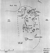 Spoonville archaeological site - burial map of mound 2
 -
 Spoonville archaeological site - 1969 excavation, copper, fint, and mica artifacts
 -
 Spoonville archaeological site - artifacts from early excavations housed at Field Museum


References[edit]
- ^ a b "National Register Information System". National Register of Historic Places. National Park Service. July 9, 2010.
- ^ The Spoonville site is listed by the NRIS as "Address Restricted." However, the Ottawa County Park System gives the general location (Marjorie Bethke Viveen, Historic River Road: A Self-Guided Auto Tour for all Seasons (PDF), Ottawa County Parks). Geo-coordinates are approximate.
- ^ Mandi L. Yoes (1998), "Instrumental Neutron Activation Analysis of Middle Woodland Ceramics: An Interim Report", GVSU McNair Scholars Journal, 2
- ^ William A. Lovis; Charles E. Cleland (2004), An Upper Great Lakes archaeological odyssey: essays in honor of Charles E. Cleland, Cranbrook Institute of Science, p. 19, ISBN 9780814331972
- ^ United States Federal Highway Administration (2010), US-31 from I-196 in Allegan County North to I-96 in Muskegon County: Environmental Impact Statement, pp. 4–43
- ^ a b Kevin Collier (July 22, 2015), "Remains of ancient civilization discovered at Crockery Creek", Grand Haven Tribune
- ^ a b HISTORY OF OTTAWA COUNTRY, HR Page & co., 1882, pp. 18, 122
- ^ a b John Baldwin (1984), "Spoonville - Classic Michigan Hopewell" (PDF), Ohio Archaeologist, 34 (4): 32–39, hdl:1811/55871
- ^ Hiram Potts (1892), Historical and Business Compendium of Ottawa County, Michigan, Volume 1, Potts & Conger, pp. 44–45
Further reading[edit]
- Terrance J. Martin (1975), "Animal Remains from the Spoonville Site, 20-Ot-1, Ottawa County, Michigan", Southeastern Archaeological Conference Newsletter, 21 (1): 1–8
External links[edit]
This article relating to archaeology in the United States is a stub. You can help Wikipedia by expanding it. |
This article about a property in Michigan on the National Register of Historic Places is a stub. You can help Wikipedia by expanding it. |